Bibbulmun Track Planning Guide
The summary: The Bibbulmun Track is a 1000km long walk in Western Australia. The trail winds from Perth to Albany through forest and along the coast with relatively mild terrain. At its bare minimum, planning can consist solely of choosing appropriate gear (a standard three season gear list warm down to approximately 0°C is often appropriate), and having a form of navigation (we liked using the FarOut app in conjunction with Gaia GPS). Food can be purchased in towns along the way. The main aspect that can require care is timing the four inlet crossings (these are rarely an issue).
When to walk
People walk on the Bibbulmun track all year round, however, the best time to walk the entire trail is undoubtedly spring. This is wildflower season and was the highlight of our trip. Walking during summer is dangerous due to the limited water supply (water tanks may be empty) and the high bushfire risk. Walking during winter is absolutely possible, and will just be wetter and colder. Autumn offers the prospect of changing forest colours but misses out on the wildflowers.


Track difficulty (pros and cons)
Things that could make the track easier or more enjoyable:
- You can resupply in towns along the way (every 100km on average)
- The trail is well marked and maintained (mostly by track volunteers)
- The Bibbulmun Facebook group is very active for asking questions and getting information about recent track conditions
- There are shelters every 15-25km
- Water is available at all shelters (unless the tanks have dried up)
- The terrain is relatively mild (see section stats)
- In spring, the wildflowers are spectacular
- Pleasant walking temperatures during spring and autumn
Things that could make the track more difficult or less enjoyable:
- Have to contend with ticks and snakes depending on time of year
- The shelters attract mice and rats at night
- Inlet crossings could be problematic
- It can be busy (some shelters may be full)
- Lack of prominence and mountain views
Cost
Discounting the cost of gear (which can get quite pricey depending on your taste for DCF), below is a summary of how much the Bibbulmun cost us at the time of walking (September 2021).
Accommodation: $346.00 (including one night in Albany)
Groceries: $602.70
Eating out: $336.50 (including a celebratory lunch to finish in Albany)
Other: Tree tops walk ($21pp), bus from Albany to Perth ($67pp)
Total cost: $1461.2 ($730.6 per person per month)
It is important to note that many would consider this a relatively cheap walk along the Bibbulmun. We only had one rest day and always looked for the cheapest places to stay when in towns.
Gear
In spring, a three season gear list warm down to approximately 0°C is appropriate for most Bibbulmun hikers. Note that it can be colder at night sleeping in shelters compared to an enclosed tent. To view our gear list at the time of walking (September-October 2021), see Bibbulmun Gear List + Analysis. To see our recommended gear list for solo walkers, see Bibbulmun Ultralight Solo Gear List.
Section distance and elevation stats
The Bibbulmun is often quoted as being 1000km long. According to the FarOut app the track is 947km. However, once you factor in detours to shelters and towns we think the 1000km estimation is pretty accurate. Again using FarOut, the track has an average elevation change of 44.7m per km. That means, on average, there is ~22m up and ~22m down per km. The Bibbulmun is relatively flat, which you can see by comparing it to other popular tracks:
Comparing the steepness and distance of famous hikes
| Walk | Distance (km) | Elevation Change (m/km) | Distance (mi) | Elevation Change (ft/mi) | Location |
|---|---|---|---|---|---|
| Bibbulmun Track | 947 | 44.7 | 588.4 | 236 | Australia (WA) |
| Cape to Cape Track | 126 | 37.7 | 78.3 | 199.1 | Australia (WA) |
| Larapinta Trail | 221.8 | 49.1 | 137.8 | 259.2 | Australia (NT) |
| Heysen Trail | 1077 | 40.4 | 669.2 | 213.3 | Australia (SA) |
| Australian Alps Walking Track (AAWT) | 680 | 81.7 | 422.5 | 431.4 | Australia (VIC, NSW, ACT) |
| Six Foot Track | 44 | 70 | 27.3 | 369.6 | Australia (NSW) |
| Great North Walk | 268 | 53.1 | 166.5 | 280.4 | Australia (NSW) |
| Great Ocean Walk | 96 | 62 | 59.7 | 327.4 | Australia (VIC) |
| Great South West Walk | 252.9 | 32.6 | 157.1 | 172.1 | Australia (VIC) |
| South Coast Track | 73.4 | 77.7 | 45.6 | 410.3 | Australia (TAS) |
| Overland Track (no side trips) | 71 | 58.7 | 44.1 | 309.9 | Australia (TAS) |
| Western Arthurs (full loop) | 76.1 | 111.9 | 47.3 | 590.8 | Australia (TAS) |
| Three Capes Track | 39.5 | 82.3 | 24.5 | 434.5 | Australia (TAS) |
| Te Araroa | 3000 | 44.2 | 1864.1 | 233.4 | New Zealand |
| Pacific Crest Trail | 4265 | 65.6 | 2650 | 346.4 | USA (CA, OR, WA) |
| Appalachian Trail | 3364 | 77.6 | 2090.3 | 409.7 | USA (East Coast) |
Additionally, the difficulty between sections doesn’t vary much. You can see this by comparing the distance and average elevation change for each section:
| Section | Distance (km) | Elevation Change (m/km) | Distance (mi) | Elevation Change (ft/mi) |
| Kalamunda – Dwellingup | 198.4 | 49.1 | 123.3 | 259.2 |
| Dwellingup – Collie | 124.3 | 42.3 | 77.2 | 223.3 |
| Collie – Balingup | 83.5 | 42.8 | 51.9 | 225.9 |
| Balingup – Donnelly River | 55.7 | 46.8 | 34.6 | 247.1 |
| Donnelly River – Pemberton | 100.2 | 52.1 | 62.3 | 275.1 |
| Pemberton – Northcliffe | 55.2 | 53 | 34.3 | 279.8 |
| Northcliffe – Walpole | 137.1 | 37 | 85.2 | 195.4 |
| Walpole – Denmark | 124.5 | 44.2 | 77.4 | 233.4 |
| Denmark – Albany | 94.8 | 38.2 | 58.9 | 201.7 |
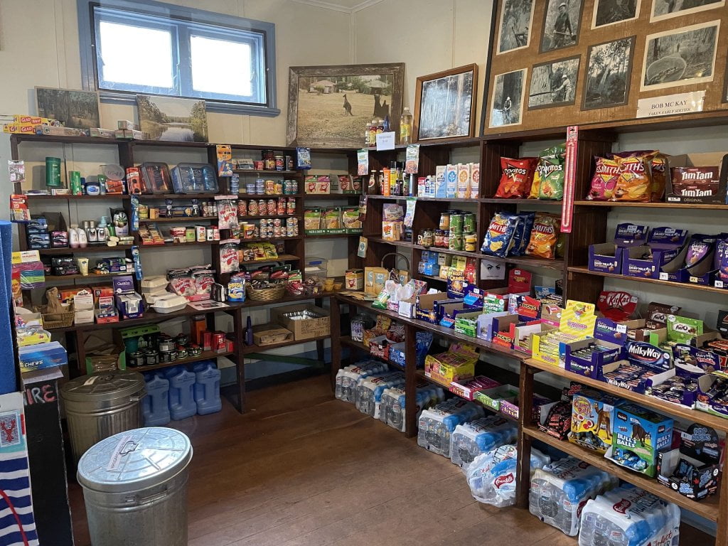
Resupply
Provided you don’t have any dietary requirements, we recommend resupplying in towns along the way rather than posting food ahead of schedule. This is because the Bibbulmun passes through resupply towns every 55-200km (100km on average). In general, we found that the grocery stores in towns cater well to hikers despite the occasional limited stock.
These are what we think are the pros and cons of resupplying in towns versus posting food ahead of schedule.
| Resupplying in Towns | Posting food | |
|---|---|---|
| Pros | – Simple and requires less planning – The track passes through towns so there are no/minimal detours to buy food – You get to fantasise about what you want to buy at the next supermarket and don’t have to eat another packet of that food you packed heaps of because you thought you would never get sick of it over 1000km | – Easier to cater towards dietary requirements – Might be cheaper to buy food in bulk (excluding the cost to post and hold food) – You can choose a wider range of foods and aren’t limited by the available supply in small towns – If desired, you can make your own dehydrated meals, which will likely be nicer than those you buy in store |
| Cons | – Can be expensive in small towns – Can have limited supply (particularly an issue if you have dietary requirements or are a picky eater) | – Requires more effort and planning ahead of schedule – You might not know what you will want to eat – You may not know how much food you will need (this could be true if it is your first long distance hike) – Food might not be as fresh if you re-package food to split between different drops |
Resupply towns
Dwellingup: General store that caters well to hikers (dehydrated meals, instant mash potato, chips, chocolate, instant noodles, milk powder). Fresh produce available (cheese, fruit, vegetables, bread). A bit pricey but no problems with variety for us.
Collie: Large mining town, easy resupply at either Woolworths or Coles. Should be able to cater for people with dietary requirements.
Balingup: Small general store. Fewer options than Dwellingup but no issues for us. Standard snack foods (chips, chocolate, crackers) with a very limited supply of fresh produce (bread, cheese, fruit). A bit pricey.
Donnelly River: The smallest and most expensive resupply along the track. We were able to resupply here but emptied the store of certain produce (oats, milk power and museli bars). Mostly sells snack foods (chips, lollies, chocolate, biscuits) and a few dehydrated pasta meals that might appeal to hikers. No fresh produce. Would be hard to resupply here if you have dietary requirements or are in a group of more than 2-3 people.
Pemberton: Resupply at the IGA. Great range of options (on par with Collie but marginally more expensive). Should be able to cater for people with dietary requirements.
Northcliffe: Small general store and very expensive. Decent range of options but not as good as Dwellingup.
Walpole: Resupply at the IGA. Good range of options (on par with Pemberton). Should be able to cater for people with dietary requirements.
Denmark: Resupply at the IGA. Good range of options (on par with Pemberton and Walpole). Should be able to cater for people with dietary requirements.
Our best resupply: Collie
Our most limited resupply: Donnelly River


Other places to resupply
Three Ways Roadhouse (at North Bannister): Petrol station with standard snacks (chips, lollies, crackers). They also sell hot pies, coffee and ice cream. Perhaps good for a top up but would be hard to do a full resupply here. You can post food here which is a popular method for those starting their hike and wanting to shorten the long ~200km carry from Kalamunda to Dwellingup.
Peaceful Bay: Small store (it would be excessive to call it a general store). Few options and expensive. Some of the items they sell include bread, crackers, biscuits, chocolate and cold drinks. Stock was very low when we passed through. Might be good for a top up but wouldn’t recommend for a full resupply. We would recommend their fish and chips though!
What about fuel?
We did not take a stove when we walked meaning we didn’t need to buy fuel canisters or methylated spirits along the way. However, we were surprised at how many places had fuel and it is certainly possible to expect to replenish fuel frequently. We would recommend looking at posts on the Bibbulmun Track Facebook page for exact stock updates.
Accommodation
The track passes through towns every 55-200km. Below, we outline the places we stayed at along our walk, the facilities provided, and the cost. We did not book in advance for any of the following and had no issues with availability despite the track being busier than normal.
Dwellingup: Dwellingup Caravan Park, ‘hikers room’. We paid for one room ($30pp) which provided a basic small room with a bunk bed, table and a place to recharge. Access to the communal bathrooms and kitchen (only a microwave) is provided. Consider booking in advance if you want a hikers room (there are only five available). Other options are available (tent sites and cabins) if these are fully booked.
Pemberton: Pemberton Youth Hostel. $10pp which provided a bunk bed, heater and places to recharge. Access to communal kitchens and bathrooms was provided. Cheap but you get what you pay for (our sheets were dirty!). At the time we passed through, the youth hostel was closing so it may be gone in the near future.
Walpole: Tingle All Over, $50 for a private room (double bed and places to recharge). Access to the communal kitchen (oven, microwave, fridges and stove) and bathroom (free shampoo and soap) provided. Very clean and our favourite place we stayed at.
Peaceful Bay: $32 for an unpowered tent site. You can still stay here if you arrive after reception has closed and pay in the morning. Access to communal bathrooms and kitchen (microwave and fridge + recharge) provided.
Denmark: Blue Wren Backpackers, $83 for private double room with attached bathroom. Access to communal kitchen (oven, fridge, microwave and stove) provided. Consider booking in advance if it is peak season. Very clean and the owner was helpful and friendly.
Albany: 1849 Backpackers Hostel, $69 for private double room. Access to communal bathrooms and kitchen (oven, stove, microwave and fridge) provided. The drug/alcohol scene was not for us and there was loud music playing at night. One of the guys working there gave Tom a haircut and we can highly recommend the complimentary pancakes for breakfast!


Inlet crossings
There are four inlet crossings on the Bibbulmun.
Irwin Inlet
Canoes are provided to cross the inlet. The crossing is ~200m wide and was not an issue for us. It is recommended to have one person and their pack per canoe, but we both fit in one with our packs (note we have small packs and aren’t big people).
There are six canoes in total (with life jackets and paddles), but only four docks for a canoe on either side of the inlet. If you get to the other side and there is no space for your canoe to fit, you have to tie a couple of canoes to yours, paddle back to the other side to redistribute the canoes, before paddling back across. This is what we had to do when we passed through. The whole process took ~30mins despite the cross wind.
Also note that the canoes are very heavy to lift and it could be difficult for some to lift the canoe back into the shed after paddling across.
Parry Inlet
We crossed at medium-high tide and it wasn’t an issue (knee deep), but conditions may differ during different seasons. It pays to pick the best route across the inlet, we walked further out into the ocean than anticipated because the water was shallower there.
If the crossing is too high, you can either wait for the tide to go out or use the alternative route provided by the Bibbulmun Foundation (also on the FarOut app). Information about the tides can be found online (e.g. Willy Weather).
Wilson Inlet (Denmark)
Leaving Denmark, there are four options to cross the Wilson Inlet.
- Cross the inlet at the mouth: Not recommended. The surrounding environment is ecologically threatened and there is no formed path.
- Take the ferry: This was not an option for us as the service was inoperable at the time of walking.
- Get a lift to the ferry drop off point: There are several companies that offer lifts around the inlet. See the Bibbulmun Track website for current operators.
- Walk around the inlet to Nullaki: Follow the Denmark-Nornalup Heritage Trail before walking along bitumen roads around the inlet. The highway walking is unpleasant but doesn’t last long. Most of the walking is on quiet country roads.
We chose to walk around but in the future would get a lift as it wasn’t a whole lot of fun.
Torbay Inlet
We crossed at low tide and it wasn’t an issue (ankle deep), but conditions may differ during different seasons. As with the Parry inlet, ensure you pick the shallowest route across the inlet (which is not always the closest to the beach).
If the crossing is too high, you can either wait for the tide to go out or use the alternative route provided by the Bibbulmun Foundation (also on the FarOut app). Information about the tides can be found online.


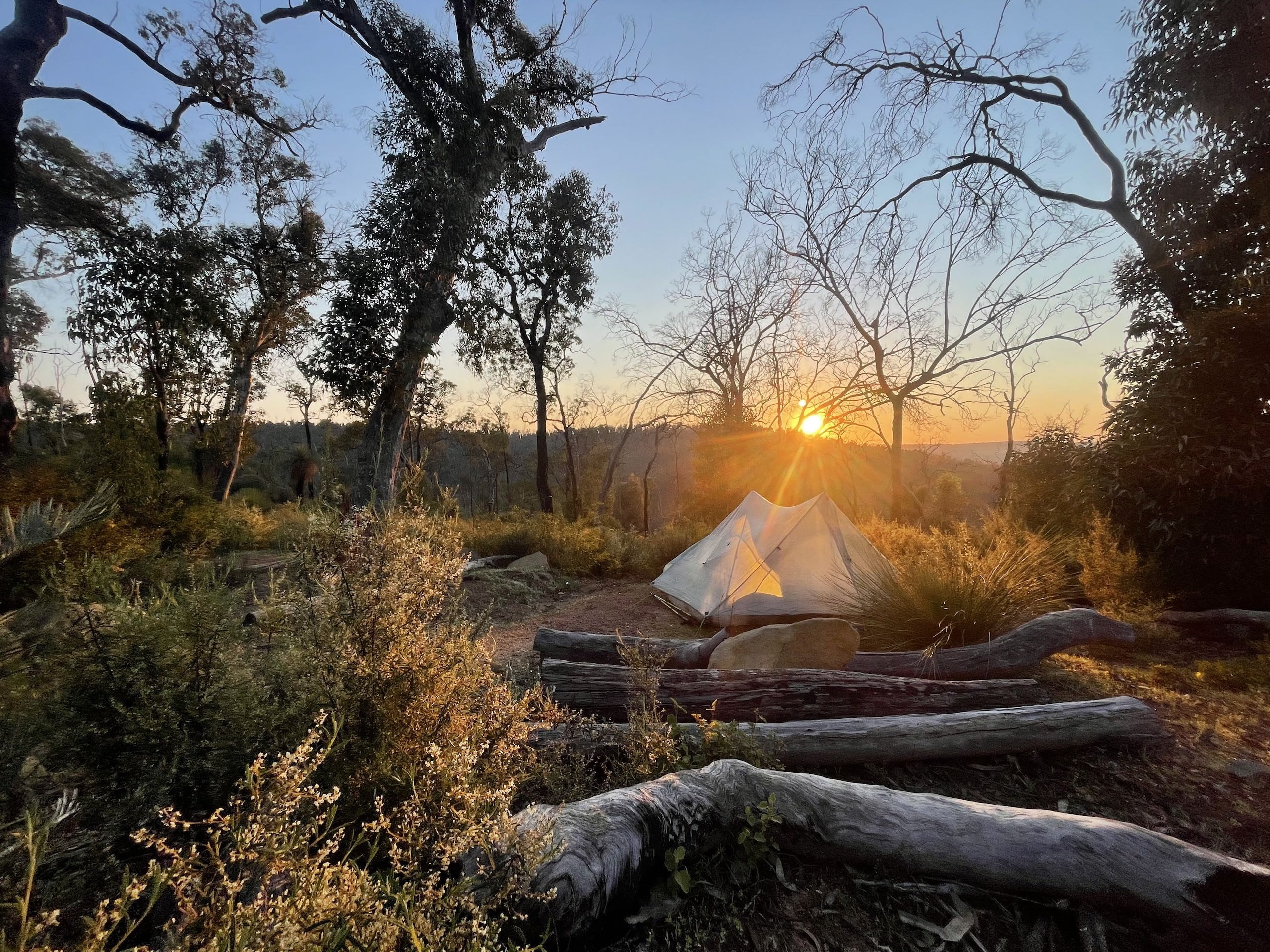
Shelters and facilities
There are shelters along the Bibbulmun track every 15-25km, sleeping between 8-15 people each. When hiking the Bibbulmun, you are only meant to camp at the shelters and it is essential that you still carry a tent in spite of these shelters. You never know if there is going to be space for you to sleep in them as they operate on a first come first served basis (although groups of 8 or more must wait until 6pm to occupy the shelters).
The shelters are maintained by track volunteers and are generally in very good condition. Every shelter has an accompanying toilet (although there is no guarantee there will be toilet paper), a picnic table and one or two water tanks. Multiple tent sites surround the shelters. There are two different types of shelters: wooden shelters and rammed earth shelters (mostly in the southern regions).
Not all shelters are located in areas that permit campfires. There will be information at each shelter outlining whether this is the case or not. Those which permit campfires have a fire pit.
All shelters have information booklets about the flora and fauna of the surrounding region. These make for an interesting read and can help you know what to look out for on the trail.
Unfortunately, due to the large amount of human activity, some of the shelters attract rodents at night in the search for food. It is recommended that you hang your pack to avoid your food becoming a target. Some shelters have hooks for you to hang your packs, whilst at others you may need to get a bit more creative (a common tactic is to wedge a stick in between the grates on the roof to hang your pack off).
Everyone seemed to have their own proprietary method of hanging packs, telling stories of rodents performing magical acrobatic feats in pursuit of food. Where possible, we placed our food in the plastic tubs provided in shelters where mice are more of a problem. We also used OPSAK ‘odour proof’ bags to store our food and we never had any problems hanging our packs from the roof.
Some people brought fishing wire or other means to hang their food or packs but it seemed simpler (and lighter) to just hang our packs from the roof using their roll top drybag closures.


Shelters with the best views (in our opinion):
- Helena
- Possum Springs
- Blackwood
- Schafer
- Mt Chance (the good views being at the top of Mt Chance)


Water availability
The most reliable water source along the Bibbulmun comes from the water tanks at the shelters (except during summer when you run the risk of tanks being empty). We recommend purifying the water from the tanks. Most tanks had clear water but some were more ‘earthy’. We heard stories about another water tank that was previously infested with mosquito larvae!
The water at the shelters should be used in moderation to ensure that there is sufficient water for all hikers coming through. If possible, the water should only be used for cooking and drinking. Empty tanks will be reported on the Bibbulmun Foundation page, and likely mentioned on the Facebook page.
Outside of shelters, there are lots of rivers and streams in most sections and we never carried more than 1.5L each (in spring).
Wildlife
Wildflowers
Walking during spring provides an abundance of wildflowers and are fun to look out for. These provide a burst of colour and are often not found, or much harder to find, in the eastern states. We would recommend walking during wildflower season to make the most of this flora.


Snakes
In late spring with rising temperatures, snake sightings are often a daily occurrence. Apart from having a SOS beacon, taking a snake bandage (and knowing how to use it), snakes aren’t worth stressing about. They might provide an instinctive fright when you see one, but their danger is often overstated and they don’t have much interest in you unless you provoke them (i.e. by stepping on them).
Mice
You can expect that there will be mice and/or other rodents at most shelters along the track. As such, it is recommended that you hang your pack at night to prevent mice from chewing through your pack and eating your food. We heard many stories about acrobatic mice who ate their way through all sorts of fabrics to get food! For us, this meant that we didn’t take our 3/4 length mats to sleep on, as we would normally use our packs with food for our feet. We placed our food in storage containers when provided.


Ticks
Ticks are prevalent along the entire track. We saw both pepper ticks (small and black) and kangaroo ticks (larger and brown). We would recommend taking some form of tick removal with you for your walk. We took the Tick Tox tick removal, which freezes (and kills) the tick instantly. We used this once to kill a pepper tick, and found it to be effective despite having to remove the tick with tweezers afterwards. We were impressed that there was no red mark left on the skin after the freeze.
Before starting our walk, we soaked our clothes in permethrin (using Equip Debugger) in an attempt to deter ticks and other insects. There is no way to know how well this worked, however, we were happy with how few ticks we encountered compared to other hikers and would do it again if we walked the Bibbulmun in the future.
Other tactics we learnt to avoid ticks include wearing long pants when we sat down for breaks and tucking them into our socks. Additionally, we used our trekking poles to brush grass trees and other shrub that overlapped the track aside before passing through. In doing so, we hoped that should ticks be present, they would fall onto the ground rather than onto us.


Kangaroos & emus & echidnas
Like most walks in Australia, there is no shortage of kangaroos. Of more excitement to us were the odd emu and echidna. Be sure to keep an eye out for the emus when passing through Donnelly River, as they are notorious for stealing your food. We learnt this the hard way when an emu stole a cookie right out of Maddie’s hand!


Navigation
There are many options when it comes to navigation for the Bibbulmun. Paper maps can be purchased on the Bibbulmun Foundation website. For navigation using your phone, you can find a range of GPX files online and import them into various mapping apps. Purchasing the Bibbulmun route from the FarOut navigation app is the simplest all-in-one solution.
We personally didn’t take physical maps and were happy using our phones for navigation. The track is very well signposted. We had the GPX files uploaded to our inReach Mini as an emergency backup should both our phones fail.


Mobile phone reception
Telstra provide the best coverage along the track. We found we had reception at some point nearly every day and it was rare to go more than a day without reception. See Bibbulmun Track Mobile Network Coverage for an up-to-date account of which shelters have reception on the track.
Attractions
There are some attractions along the Bibbulmun track that are not to be missed!
The Gloucester Tree: A free attraction that scales a 58m high tree and provides some great views of the surrounding forest at the top. It is less than 5km south of Pemberton. Unfortunately for us, it was raining when we passed the tree so we decided to give it a miss.
The Tree Top Walk: Leaving Walpole heading south, the Bibbulmun passes through the Tingle forest, home to the so-called ‘Giant’ trees. The Tree Top Walk is situated roughly 30km from Walpole. It is a 600m platform walk that passes through the tree tops of the Tingles. At the time we passed through, the standard entry fee was $21pp.


Useful resources
In combination with this page, everything you need to know and for navigation should be covered by these resources:
- The Bibbulmun Track Website
- The Bibbulmun Track Facebook page
- FarOut app
If you are wanting some extra resources, you could check out:
- The UltralightAus subreddit (good for potential gear ideas and joining the ultralight community in Australia)
- GaiaGPS or MapOut (alternative phone apps for navigation)